Places
__________________________________________
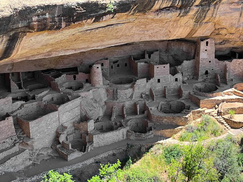
Mesa Verde
A photograph of Cliff Palace, the largest cliff dwelling in
North America, though "great houses" built on canyon
floors such as Pueblo Bonito in Chaco Canyon are much
larger. Mesa Verde has 600 cliff dwellings and 5,000 ruins
over 52,000 acres. It's the largest archaeological preserve
in the US. Cliff Palace was built and occupied between
1190 and 1260 CE, but was abandoned before 1300, most
likely due to drought. Mesa Verde is a World Heritage Site.
Most of the mesa lies above 7,000 ft with the highest point
reaching 8427 ft. It's almost entirely covered in forest.
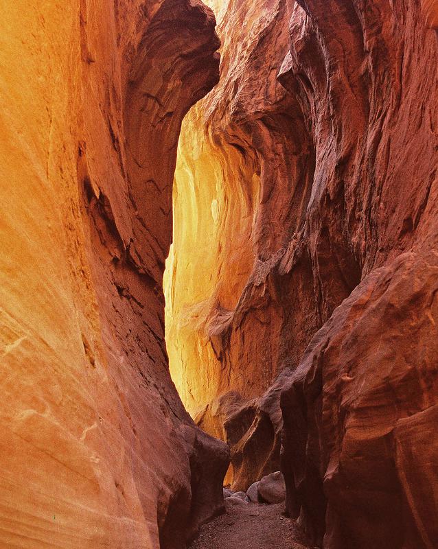
Grand Staircase-Escalante National Monument, UT
Grand Staircase-Escalante NM was established in 1996 in southern Utah
by President Bill Clinton with 1.7 million acres, later expanded to almost 1.9
million acres. It's a very remote area of the West, the last territory in the
lower 48 states to be mapped. The Grand Staircase is a series of five long
cliffs dropping from 8,000 feet at Bryce Canyon National Park to the Grand Canyon. East of the Grand Staircase is the Escalante River Canyon and its network of tributary canyons. It's full of places to explore, bordered by the
Paria River Canyon on the west. I took this photograph with a film camera
in the Dry Fork of the Coyote Gulch tributary of the Escalante River in 2000.
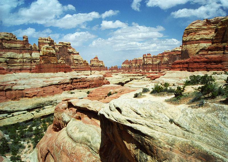
Elephant Canyon, Needles District, Canyonlands NP, UT
This is a photograph from the end of Elephant Canyon looking
back down canyon. This spot has the most stunning view of the
entire Needles District, which is saying a lot. The canyon dead-
ends here, and the shot is taken from the bench above where
Druid Arch, which rivals the best arches in Arches NP, sits. Not
easy to get to here, from Elephant Hill it takes a backpack with
a one or two night stay in one of two reserved campsites in the canyon, plus a 5-7 mile dayhike to the end of the canyon and
the arch, depending on which campsite you get. Or if you can
handle a 10.8 mile dayhike you can forego the overnight stay
in the canyon. Twenty years ago I managed it on a several day
backpack that took me to other places, but that was when I
still thought I was young in my fifties. The Needles District of
Canyonlands National Park is still my favorite of all the places
I've been in all the wild country of the Southwest.
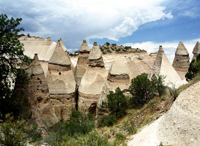
Kasha-Katuwe Tent Rocks National Monument
Generally known as Tent Rocks, it's on Cochiti Pueblo
land and is jointly managed by the BLM and the Cochiti
Tribe. The rocks are formed of pumice and tuff from
pyroclastic flows caused by volcanic eruptions in the
Jemez Mountains 6-7 million years ago, then weathered
into canyons and "tent rocks" with caps made of harder
rock at the top. There are two trails of 1.6 miles and 1.2
miles in the monument. It's a very interesting place that's
unlike anything else I know of in the US.
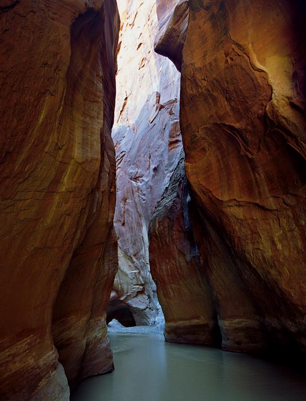
Paria River Canyon, Paria Canyon-Vermillion Cliffs Wilderness
A photograph of the narrows of the Paria River Canyon (pronounced Pah-reea)
in southern Utah at right about at the Arizona state line. The canyon runs for 95
miles from the foot of Bryce Canyon's Pink Cliffs to the Colorado River at Lee's
Ferry. It's 38 miles from the White House Trailhead on US Hwy 89 down to the Colorado. This spot is a little over 7 miles from the trailhead. The confluence with Buckskin Gulch just around the corner from this photo. The canyon here is only
about 15 feet wide with walls that go virtually straight up for 400 feet. The narrows section starts about 3 miles above this point and appears to continue for another
12 miles before widening out. It's an awe-inspiring place but a little spooky, and clearly not a place to get caught in a flash flood. There are no roads below Hwy
89, and Buckskin Gulch is the only canyon that feeds into the Paria between the trailhead and the Colorado. For the ambitious, if you have a hiking partner and
take two cars, you can do a 38-mile, one way shuttle backpack over 4-5 days by leaving a car at Lee's Ferry. I was never quite that ambitious.